Scan Date:Apr 12, 2026
Show More
Embark on a new level of tactical expertise with the all-inclusive Military GPS Survival Kit Bundle. The app combines an impressive array of 36 professional tactical and navigation applications. Plan routes, mark waypoints, and track your position with precision, all while staying informed with live updates on global conflicts. Delve into an extensive library of military manuals and PDFs for essential knowledge at your fingertips.
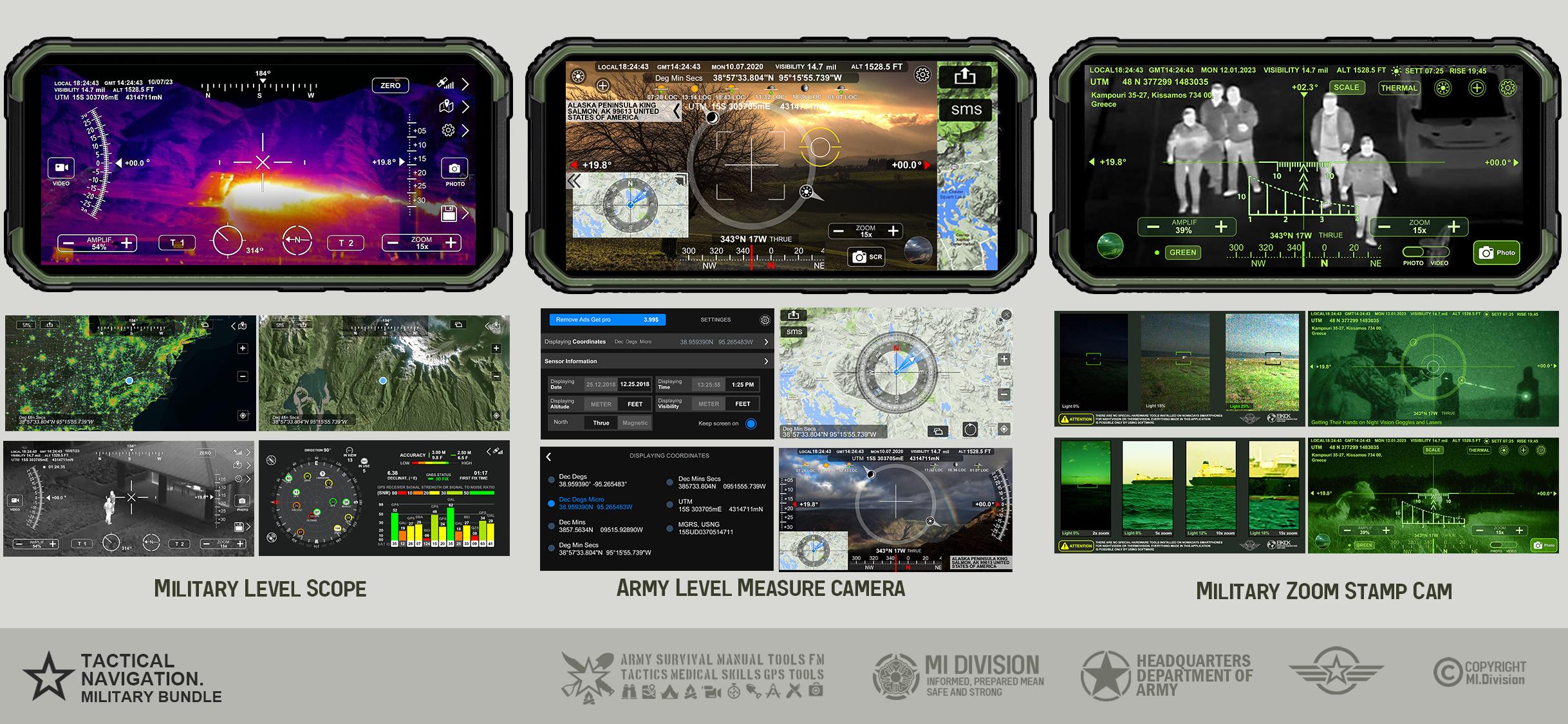
1. Stamp Camera with Compass and GPS Info
Geotag Photo & GPS Location. Notes as project name and photo description. GPS location, compass direction, altitude, map screenshot, date & time, sunrise sunset, sun moon locator.6 Coordinate types UTM MGRS
2. Altimeter Distance Tracker
Imperial and Metric unit settings. - Altitude calibrate refresh button. - GPS accuracy indicator. - GPS distance accuracy indicator. SMS your map location link
3. GPS Locations
Get, share, save, and search map coordinates of your current location. WGS84 system that is most widely used. You can easily find coordinates with an address or building name. Move map under cross pointer on the map and get 6 types of coordinates information.
4. Heading Compass
Real-time orientation to magnetic fields. It displays location, altitude, speed, magnetic field, barometric pressure, weather, sun and moon azimuth, etc.
5. Direction Compass camera
6. Waypoint Navigation
Add and determine the distance and direction to a GPS waypoint. Shows an arrow to the direction you need to go, you will have to find your own way. No data connection. Store multiple waypoints and navigate to them. You can also save their current position as a waypoint to navigate back to later.
7. GPS Status Satellite Check Navigation Pack
Use the app's satellite reports to understand the quality of the location information provided by your device. Navigate online and offline, view coordinates, number of available satellites, atomic satellite time, satellite signal quality, satellite positions, and other satellite statistics.
8. Protractor Camera with Zoom and levels
Take photos and videos without taking your look away from the Compass, level indicators, and Sun/Moon Location using high-quality zoom.
9. Cell and WIFI Towers world map
Cell Coverage World Map, Cell & Wi-Fi Towers. Speed Test. Full data on cell towers around the world. 219 countries! Large Database of Cell & Net Towers. Locate devices without GPS, explore Mobile Operator coverage, and more! Almost 36 million unique GSM Cell IDs
10. Tactical GPS UTM, MGRS, GPS Location Info, Nav Compass
Tactical GPS Info shows your current location, date & time to the second along with a scrollable map. You can copy your coordinates & locate anything you can find on the map with accurate crosshairs.
11. Barometer and Altimeter
12. Direction Compass
Accurate professional compass and the greatest tool for outdoor activities MGRS (Military Grid Reference System). Map, True heading and magnetic heading, Magnetic strength, Slope level meter, Phone Sensor status.
13. Measure Map. GPS Fields Area Calculator
Tactical pro tool for measuring areas on the map. Place your points on the map and then calculate area between all point, calculate total Area of ant Route.
14. MGRS Live Map and Military Compass
Military Grid Reference System
15. Street View & All GPS Info
16. Military Zoom Scope Stamp Camera
17. Offline Map Land Navigation
18. Tactical Combat Land Navigation
19. Medical Services World Map
20. Crime Index Live Map
and more apps inside...
App also includes:
Global Conflicts Live News - Independent global news. With the ability to view the places of military operations on the map
Army Survival Handbooks Field Manual PDFs
1. First Aid For Soldiers,
2. Soldier’s Handbook
3. Combatives
4. Military Symbols
5. Warrior Ethos Soldier Combat Skills
6. Ranger Handbook
7. Training And Qualification -individual Weapons
All handbooks are Approved for public release; distribution is unlimited
Latest Version
2.1.5Uploaded by
AhMed HeGazi
Requires Android
Android 8.0+
Category
Free Tools AppContent Rating
Everyone
Security Report
Report
Flag as inappropriateLast updated on Apr 12, 2026
- New App: Impulse Noise Decibel Meter
- Bug Fixes


APKPure - A multi-platform app store primarily focused on Android, providing extensive app-related content. Discover the app you want easier, faster, and safer, with quick and efficient downloads and installations.


