Just for your entertainment ... or your business needs.
[ ► No ads, Free Software ◄ ]
Position GPS = Waypoint = WP
GPS tool for finding GPS positions and giving cartographic, geometric and statistical information.
There are many tools available, combining WPs to create geometric shapes, routes, lists or gather information for more complex processing.
Its objective is to provide all the information and tools possible associating the user (you), GPS positions, a calculator (your smartphone).
The information and results are displayed on the map (google map).
Sport routes can be saved automatically and displayed, processed, reused by integrated GPS tools.
WPs can be recorded in different ways:
- tactile input on map
- manually enter coordinates
- via periodic automatic recording
- via buttons on the interface
The interface is intuitive and based on a simple color code.
Touch capabilities are used, click on the maps to get information specific to the selected tool, select WP, ...
4 waypoints are accessed via a color code -Green, Blue, Red, Yellow-. This is to facilitate simple treatments (quick search, triangle, quadrilateral, circles ...).
The 4 color waypoints are interchangeable with those in the global list (via the manager).
► Classic tracker GPS tool: find a GPS position like that of the car, at Grandma's, a corner with mushrooms ...
» Information given: the time remaining before contact, the distance remaining, the speed, the difference in altitude, ...
» Sound tracker function: the closer you get to a position, the smaller the difference between 2 beeps
» Compass with position of WP searched
Distance: "xxx m"
The distance separating us from the selected waypoint (for which the search is in progress)
This distance appears:
• Blue if one moves away (cold !)
• Red if you get closer (It heats up!)
• Green if you are close (= GPS accuracy)
[List of GPS tools]
------------------------
All available GPS tools use one or more of the following: current position, WPs of colors, WPs typed on the map, WPs of a list.
WPs describe geometric shapes, sets (paths), or are taken separately.
The treatments of these GPS tools provide information: distances, areas, lengths, perimeters, angles, paths, remarkable points, intersection points, projected points, heights, diagonals, medians, bisectors, incircle, circumcircle, ...
The results of the treatments are displayed on the map and on the screen.
► Information
• On the current position and WP
• Distances between WPs
• Statistics
• Proportional distance radar
► Maps
• Circles of equidistances (fixed, manual, tactile)
• Isochronous circles (fixed, manual)
• Circles of equidistance vs isochronous (fixed, manual)
• WPs display
• Nearby WPs
• Distant WPs
► Touch-mapping tools
• Distance between the current position and a WP
• Distance between 2 WP
• Cumulative distances between WP
• Polygons
• Angles
• Circles
• Triangle
• Quadrilateral
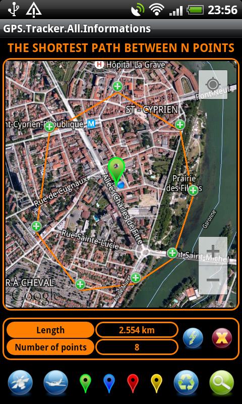
• Shortest path (between several WPs)
• Longest route
• Squares
• Segment intervals
► Specialized modules
• Distance from the horizon
• Mutual visibility between 2 objects
• Thunderstorm (analysis from thunder and lightning, determination of lightning position)
• Propagation of the sound wave
• Information about GPS satellites
► Geometry between WP colors
• Discs with the current position
• Discs between WP
• Triangle
• Quadrilateral
► Geometric Calculations
• Mid of segments
• Intersection of straight lines
• Distance from the WP to the right
• Tangent to the circle through a WP
• Intersection of circles
• Intersection of a circle and a line
► Transformations
• Rotation
• Homothetics
• Translation
• Central Symmetry
• Axial symmetry
• Trigonometry
► Operations on a set of WP
• View and route information
• Sorts, Statistics
Latest Version
2.5Uploaded by
Phuthinh Thinh Trinhphuthinh
Requires Android
Android 1.6+
Category
Free Tools AppContent Rating
Everyone
Report
Flag as inappropriateLast updated on Jun 30, 2017
►Version 2.5
» Specialized modules
* Apparent size | real size | distance of an object
» Touch-mapping tools
* Square [Side (point+point)]
* Square [Diagonal (point+point)]
* Square [Half-diagonal (center+point)]


APKPure - A multi-platform app store primarily focused on Android, providing extensive app-related content. Discover the app you want easier, faster, and safer, with quick and efficient downloads and installations.


