Scan Date:May 4, 2026
Show More
The United States of America is located on the North American Continent. The United States is bordered by the Pacific Ocean on its west coast, the Atlantic Ocean on its east coast, Canada to the north, and Mexico to the south.
The United States is a big country, and it definitely takes more effort to learn the US geography, US capitals, US states & American flags compared to other countries. Whether you're a high school student or just a curious learner, our US geography quiz 50 States will help you master US capitals, states, flags & US maps.
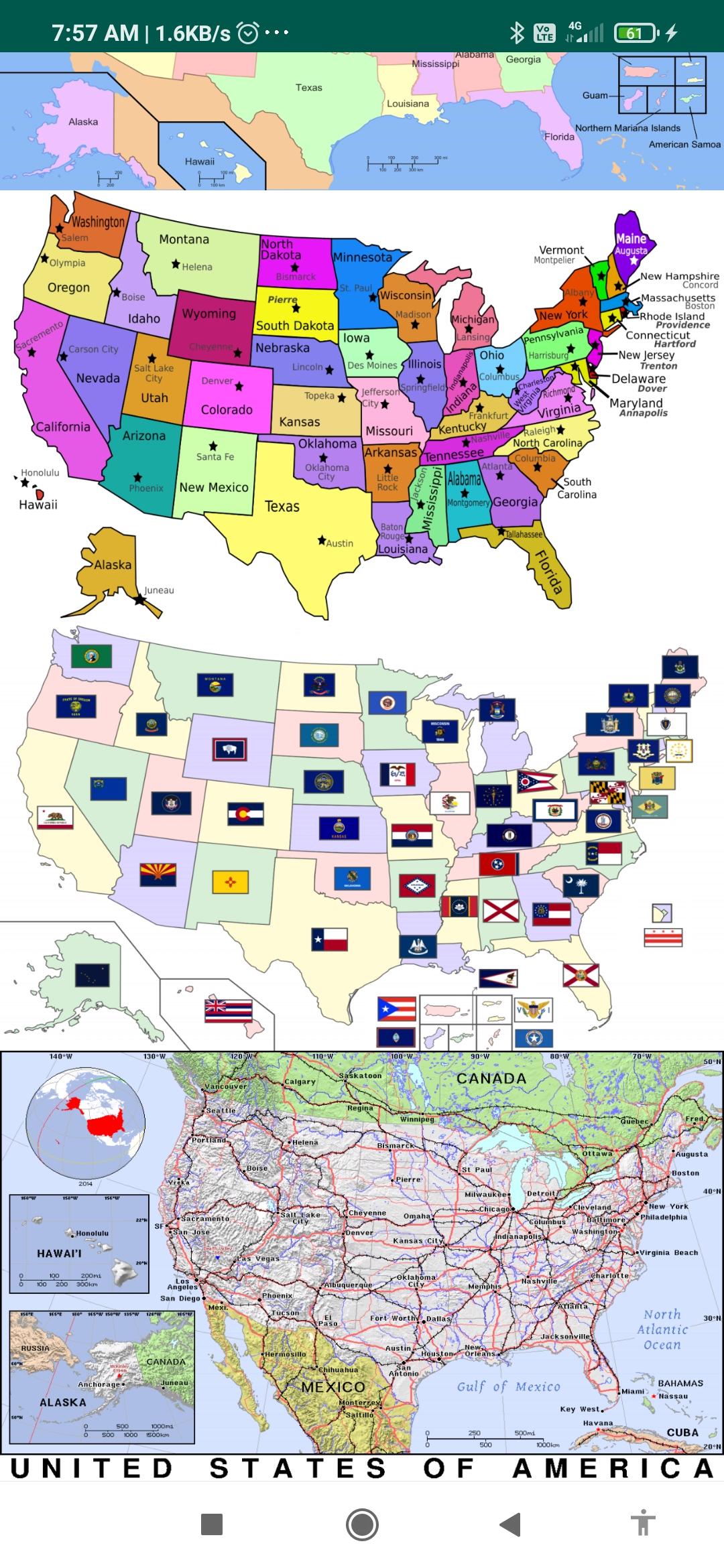
US States map contains information about all 50 US states, capitals, the state flag, and wiki links to know more about the state.
Capital Cities:- Via this Atlas app for Map Of USA you can get search for the Capital Cities of each state.
Must have mobile app features include:
50 us states map with capitals names
map of USA with states
u.s. states and capitals
united states map with cities
map of the USA with states and major cities' names
us atlas
American atlas
atlas of the united states
blank us map
political map of USA
us regions map
USA in world map
us river map
United states elevation map
topographic map of us
united states road map
This physical map of the US shows the terrain of all 50 states of the USA
List of States:
the map of Alaska, Washington dc on us map, Chicago map USA, Washington map USA, map of united states of America and Canada,
Alabama, Arizona, Arkansas, California, Colorado, Connecticut, Delaware, Florida, Georgia, Hawaii, Idaho, Illinois, Indiana, Iowa, Kansas, Kentucky, Louisiana, Maine, Maryland, Massachusetts, Michigan, Minnesota, Mississippi, Missouri, Montana, Nebraska, Nevada, New Hampshire, New Jersey, New Mexico, New York, North Carolina, North Dakota, Ohio, Oklahoma, Oregon, Pennsylvania, Rhode Island, South Carolina, South Dakota, Tennessee, Texas, Utah, Vermont, Virginia, Washington, West Virginia, Wisconsin, Wyoming.
United States Bordering Countries:
Canada, Mexico
Regional Maps:
Great Lakes, U.S. Territories, North America, World
Latest Version
1.7Uploaded by
Mhamad Malik
Requires Android
Android 6.0+
Category
Free Education AppContent Rating
Everyone
Security Report
Report
Flag as inappropriateLast updated on Mar 15, 2026
Minor bug fixes and improvements. Install or update to the newest version to check it out!


APKPure - A multi-platform app store primarily focused on Android, providing extensive app-related content. Discover the app you want easier, faster, and safer, with quick and efficient downloads and installations.


